![]()
 |
Mount Rogers VirginiaThe "Crown" of the Virginia Highlands
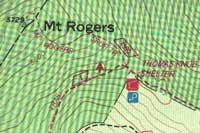
Mt. Rogers Map | Trail Information The HighlandsClose to the border of North Carolina and close to my heart
is Grayson
The Little Wilson Creek Wilderness,
Lewis
Fork Wilderness, and the Mount
Rogers National Recreation area are adjacent to Grayson
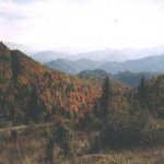
View of Massie Gap, looking towards North Carolina.
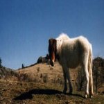
Another great feature of this area is that it is the home to
many Wild Ponies.
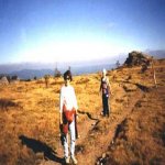
Hikers will usually catch their first glimpse of the ponies before they leave Grayson for the National Forest. The State Park as well as the National Forests are home to herds of these friendly animals. Once a year The forest Service will round up the ponies herd them to an coral and check them for any health problems. The Rhododendron Gap trail begins at Massie Gap, is blazed and is very easy to follow. There are two trail heads for hikers, one is at Massie Gap for day hikers and the other starts at a separate parking lot for backpackers. As you start your hike you will pass through a gate that was installed to keep the ponies in the park. The trail is an old road that the Park Rangers use occasionally to search for lost hikers, to maintain the fences and to round up the ponies. There is a short steep climb and in just a few short minutes you will see your first view.
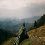
View at the top of Massie Gap. The trail curves to the left and will intersect with the Appalachian Trail shortly after completing your first climb. Continue straight on the trail, don't turn on the AT. From here you will see steps over the fence straight ahead on the Wilburn Ridge Trail. Take these steps and begin your climb up that big pile of rocks called Wilburn Ridge. After about a quarter of a mile you will find yourself on top of the world with panoramic views. A 360 degree view that's reminiscent Rocky Mountain views. In the Spring the balds are covered with colorful wildflowers. It's so beautiful you won't mind the other hikers that seem to be drawn to this ridge.
Steve at the top of Wilburn Ridge. After lingering on this high point descend to a small gap and climb up the other rock pile that's part of the ridge. Hurry! On this high point there is a slightly different view that is worth the extra climb. Another great view! Who can get enough of these? Descend again.
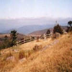
Laura and Brad on the Appalachian Trail. This is where the trails become convoluted and for that reason we strongly suggest taking a map on this hike. They can be purchased at the visitors Center, the front gate or the Park office. At this point the Rhododendron Gap Trail joins the Appalachian Trail in an open area. Continue over another ridge until you reach another trail junction. Looking forward towards the split rail fence is a beautiful view of the Virginia Mountains and countryside. This grassy spot is a very popular junction for hikers to take a break.
Lewis Fork Wilderness. The Lewis Fork Wilderness sign to the left is on the AT. Follow the AT and enter a bushy, shrubby, pine forest that is a characteristic of high elevations. There are many pony trails in here and the chances of seeing more ponies are good. This patch of woods is another change of landscape that is very pleasing to the eye. This is also an excellent place to camp because this smattering of trees shelter tents from the strong winds that frequent these rocky, treeless mountains.
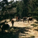
Wild ponies in the Lewis Fork Wilderness Area. After winding through this patch of trees the trail continues on to the Thomas Knob Shelter. This is a unique shelter, on the edge of the forest, is unusual because it has a latrine and a second floor. After leaving the shelter the trail enters an open field. Deer are frequently spotted on this section of trail.
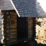
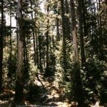
The two level Thomas Knob Shelter. Just ahead is another turnstile to negotiate and the spur trail for Mt. Rogers. Shortly after turning on the trail you leave the open field and enter a Spruce forest. The hike turns into a walk through a mossy tunnel of spruce trees. The forest floor is thick with fallen needles. The forest interior is so dark that it lacks under story trees or shrubs. The hike takes you through yet another change ! At 5729 feet Mt. Rogers is the highest point in Virginia. There isn't a view from the summit of Mt. Rogers but this perfect example of a Boreal Forest made the side trip worth it.
The spruce-fir forest at the summit of Mt. Rogers. Double back to the Lewis Fork Wilderness sign and turn right on the Crest Trail. This open area is frequently used by hikers as a camping area because it is close to a spring. This has been a dry year and the spring is no longer there. There is, however, a water source just ahead on the Rhododendron Gap Trail. Continue to a trail on the left . This is the Rhododendron Gap trail and takes you back to Massie Gap. After walking approximately 1000 feet look to the right of the trail. The wet spot you see is good enough to filter water from. As you walk back to Massie Gap you might not be able to risk the temptation to climb up to Wilburn Ridge again! The total mileage for this hike to Mount Rogers from Massie Gap and back is approximately 8 miles Mt. Rogers Map | Trail Information
|
||||||||||||||||
|
|
|||||||||||||||||
|
|
|||||||||||||||||
|
Find a hike by location
|
|||||||||||||||||
![]()